The Pacific Rim is often called the “Ring of Fire” due to the large number of volcanic eruptions that occur along its plate boundaries. Volcanic eruptions are the greatest single cause of natural hazard induced deaths in the Pacific, having caused over 3500 fatalities in the last 100 years.
A volcano is a mountain formed by erupted lava, rock fragments and ash. Volcanic eruptions occur when magma (molten rock) from inside the Earth rises to the surface along plate boundaries or at weak points within the plates called hotspots. There are many different types of volcanoes associated with different eruption types.
Landslides on steep, unstable fl anks can have disastrous impacts. For example during the 1985 eruption in Colombia 23,000 people were killed by a fast moving mudflow of ash and water.
Tsunamis can be triggered by violent submarine eruptions or major volcanic landslides entering the sea.
Earthquakes can be caused by the intrusion or release of magma.
Fires can be caused by hot ash, bombs or lava.
World’s climate is affected by the gases and particles forced high into the atmosphere during eruptions.
One of the most tragic and devastating tsunami in recent history occurred on 26th December 2004 just off the Indonesian province of Bande Aceh. Waves up to 30 m high battered the coastlines of Indonesia, Thailand, India, Sri Lanka and the Maldives, leaving about 300,000 people dead or missing. Whilst destructive tsunamis such as this are relatively infrequent, tsunami are common in the Pacific Ocean and can affect all of the Pacific island countries. This is because the Pacific basin is surrounded by the “Ring of Fire”, a series of tectonic plate boundaries associated with high earthquake and volcanic activity.
A tsunami (a Japanese word meaning “harbour wave”) is a series of waves, travelling at speeds of over 800 km/h in the deep ocean and often going unnoticed. They travel harmlessly until they reach the shallow water of a coastline where they slow down and steepen, cresting to heights of more than 10 m and can crash with devastating force across the shore, flooding low-lying areas and causing death and severe destruction.
Any disturbance that shifts a large volume of water away from its normal position can generate a tsunami.
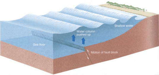
The most common cause of a tsunami is an offshore earthquake, which can cause the sea floor to abruptly lift or subside. This can disturb the overlying water column and possibly lead to a tsunami.
Backwash - Another danger from Tsunami waves is that they bring a large volume of seawater onto the land. When the water flows back out it may carry people out to sea.
Wrap around - Tsunamis tend to align themselves parallel to the shoreline so they wrap around headlands, sand spits and even whole islands, so that it can be just as dangerous on coasts not facing the tsunami source.
The Pacific Tsunami Warning Centre (PTWC) in Hawaii detects and provides warnings of potentially damaging Pacific wide tsunami. While warnings of far-source / ocean-wide tsunami can be given well in advance of the tsunami arriving, unfortunately, warnings cannot be given about a near-source tsunami because it can reach shore within 10-20 minutes of the earthquake or eruption that caused it. This was the case with the 17 July 1998 event in Aitape, Papua New Guinea.
Similarly, a submarine volcanic eruption creates an upward force that lifts the water column above the volcano leading to the generation of a tsunami. A submarine landslide can also generate a tsunami from the sudden down-slope movement and the slumping of sea floor sediments. These landslides are most often the result of an earthquake and are occasionally due to a volcanic eruption. In addition, coastal landslides and volcanic cone collapses that send tons of debris spilling into the water can also result in tsunami.
Tsunami can severely impact coastal areas, completely inundating low-lying coastal areas, destroying buildings, damaging infrastructure, flattening trees, churning up soil and even washing away entire villages. The inundation can also cause severe coastal erosion and affect areas upstream from the coast since tsunami waves can travel up rivers and streams from the ocean
Tsunami waves travel at 36-54 km/h in shallow water, faster than most people can run. This enormous momentum means that the force of the waves can move large rocks weighing several tons, along with boats and other debris. People can be caught up in the wave and tossed about, choking on seawater and suffering injuries due to the debris.
During major tsunami, fatalities and damage result not only from the force of the waves themselves, but also from the accompanying debris churned up as the wave surges across the shore, such as broken glass, torn metal, parts of buildings and uprooted trees.
Landslides are a serious geological hazard affecting the mountainous, volcanic islands of the Pacific region namely Fiji, Papua New Guinea, Samoa, Solomon Islands, Vanuatu and the Federated States of Micronesia.
Globally, landslides are more widespread than any other geological event and cause thousands of deaths and injuries each year and can cost billions in damages.
Landslides occur when rock, soil or waste becomes unstable and moves downward under the influence of gravity. Many factors contribute to the instability of slopes, but the main factors that pre-dispose a slope’s stability are its geology, its geometry and its (pore)-water conditions.
Three distinct physical events occur during a landslide:

Landslides travel at a variety of speeds from a few millimeters a year to over 100 metres per second and are frequently associated with other natural hazards. Natural events and human activity can also cause slope failures.
Landslides can be fast, sudden and can cover large areas, engulfing people, crops, animals and buildings. Areas prone to landslide hazards include old landslides, slopes dried out and cleared by fire, the bases of steep slopes, drainage channels and developed hillsides.
Landslides cause tremendous damage to property and infrastructure, as well as numerous fatalities and injuries.
One of the major problems is that landslides can cut off roads and communication lines, leaving people stranded. Landslides also affect the viability of food gardens and cash cropping areas on which rural Pacific economies are heavily dependent.
Very large landslides can have an enormous effect on the surrounding geography. They create huge gaps in the vista and dam rivers, flooding surrounding areas and creating lakes.
Failure of a landslide dam, which has trapped large volumes of water behind it, can cause catastrophic flooding downstream.
Large landslides underwater or into the sea may create tsunamis.
Landslides cause severe soil erosion and deposit this sediment in rivers, which then carry it into the sea causing considerable damage to the surrounding coral reefs.
Tropical cyclones (also known as typhoons or hurricanes) affect nearly all Pacifi c island countries and are the most frequent hazard to affect the region, with around 7- 8 cyclones occurring every year. As a result of climate change cyclone frequency has doubled in the last decade.
The cyclone season in the southern hemisphere runs from October to May and in the northern hemisphere from May to October but some cyclones do occur outside the season.

A tropical cyclone is a violent rotating windstorm that develops over warm tropical waters warmer than 26.5 ºC and located between 5º and 15º latitude. Cyclones begin as thunderstorms, which due to the Earth’s spin revolve clockwise in the southern hemisphere and anticlockwise in the northern hemisphere. These storms rise up to 10 km into the atmosphere and can be up to 2000 km across. As the cyclone becomes organised, a calm clear area called the ‘eye’ forms at its centre. The eye is typically 10-50 km wide and is surrounded by a dense ring of cloud known as the eye wall, which marks the belt of strongest winds. Tropical cyclones can persist for many days and follow unpredictable paths, however in the South Pacific they usually move southeast. The warmth of the tropical waters provides the energy to fuel cyclones. As a result, they tend to weaken and dissipate as they move over significant island landmasses or cooler waters further south, forming rain depressions.
There is a well established network of cyclone warning centres throughout the region. Places like the Regional Specialised Meteorological Centre (RSMC) in Nadi monitor, track and name tropical cyclones as well as provide warning services to Pacifi c island countries. Similar services are provided for Papua New Guinea and Solomon Islands by the Australian Bureau of Meteorology’s Tropical Cyclone Warning Centres. French-speaking countries are looked after by Meteo-France and American affiliated states by the National Oceanic Atmospheric Administration (NOAA).
Strong winds can continue for hours, days even, causing widespread damage to buildings, infrastructure and vegetation and causing loss of life. Wind speed levels of a tropical cyclone are:
Gale force winds: 63-87 km/h
Storm force winds: 88-117 km/h
Hurricane force winds: 117+ km/h
Torrential rains can result in widespread flash flooding and river flooding. Up to 600 mm and more of high intensity rain can be produced in one day. These rains can also trigger landslides in hilly areas, which may already be sodden due to previous rains.
Storm surges and waves created by low atmospheric pressure and strong cyclonic winds blowing over long distances. A storm surge is a raised dome of seawater about 60-80 km wide and 2-5 m higher than normal sea level. As the cyclone makes landfall, storm surge and waves inundate coastal areas. At the coast, storm surge and waves are the greatest threat to life and property and also cause severe coastal erosion. In low-lying atolls, a surge may inundate the whole island.
Further Saltspray and Lightning can cause considerable damage to crops, forests and infrastructure.
River flooding is a frequent risk to high volcanic Pacific island countries due to high rainfall, small river catchment areas and low lying coastal areas. Whilst floods cause considerable damage to people and property, some benefits of flooding include an increase in soil fertility due to sediments being deposited on flood plains, pollutants being washed away and groundwater being replenished.
However, currently our knowledge of Pacific island river system behavior remains poor.
Inland flooding results from heavy and prolonged rainfall, when the water level in rivers and streams rises over the banks and inundates the surrounding land.

Many factors influence the intensity of a flood:
Floods disturb fragile island economies by affecting individuals, businesses, insurance companies and governments. The costs of flooding are high. For example, Fiji’s economy suffers annually losses of some FJD 20 million on average due to flooding.
Floods have tremendous impacts to life and property, with 10 people on average being killed every year in Fiji alone. Buildings, personal belongings and stock get washed away or seriously damaged by muddy water. Businesses and services become disrupted for several days and people need to be evacuated from flooded areas, sometimes for weeks.
Animals and crops get drowned and washed away and sometimes soil is saturated for months afterwards, preventing new planting.
Floods can seriously affect transport lines with airports closed, roads submerged and bridges washed away.
Spread of epidemics such as cholera is frequently associated with floods due to the flooding of septic tanks and sewage systems contaminating drinking water.